
We spent the night of Saturday, October 21 in the city of Blenheim, a small city on the northeast side of the South Island. We only saw the city center at night but it appeared to be nice. It wasn’t quaint like a European city center, but it was well laid out with pedestrian malls, shops along well planned out streets and squares. It was very unlike the sprawl of Ilam where I live or Cockeysville where I lived in Baltimore.
But, people don’t come to Blenheim for the city center. They come to this region because the town is conveniently located in the midst of New Zealand’s largest wine producing region. There are more than fifty wineries and acres of vineyards dotted around Blenheim. With so many wineries located close to town and literally next door to each other, it is easy to cycle from one to another.
On Sunday morning, after checking the weather and deciding to head west, Nils and I opted to stop by the Saint Clair winery which was conveniently situated near the highway. The winery claims to be one of the last of the privately owned family wineries in the area and they export to the US. After a quick sampling and the purchase of a few bottles, we headed west through the drizzle.
The goal of our drive was the Nelson Lakes region which offers numerous tramps of varying lengths. We arrived at the information office at Lake as the drizzle was letting up and after speaking with the woman at the office, decided on a 1 1/2 hour tramp along the lake and up one of the hills. We chose this one because it was under trees for most of the way which would offer some protection from the rain. The tramp was really nice and we kept our eyes out for Kiwi birds which live in the area, but didn’t see any. What we did see was a lot of a black fungus that grew on everything. After doing some reading, it appears that the trees may have been beech trees which attract insects that produce honeydew. The black fungus was (Capnodium fungus) which grows on the surplus nectar exuding over the plant and sometimes even the ground.

Our tramp ended near the lake and by walking through some trees we came to a beach with offered views of the surrounding mountains, with only their bases visible in a grey mist which shrouded everything. Fortunately, we chose our walk wisely because soon after we finished, the rain started again. We continued to drive west and came to more portions of the highway which were only one lane wide. I recognized one of them from the bus trip that I had made in the area when I visited in 2004. The road clings to the side of a steep hill with a river on one side and a shear, rock wall on the other. The road goes around a series of bends and you have to hope that nothing is coming from the other direction. We just followed another car into this portion of the road and hoped for the best.
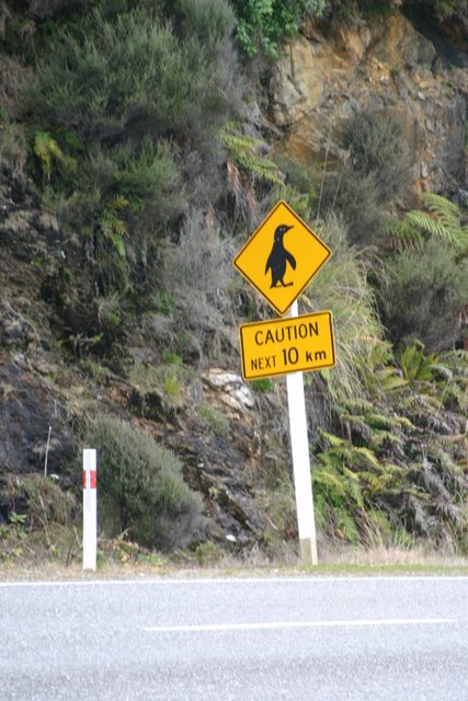 Our westward travel brought us out to Westport on the west coast of the island. We didn’t go into town but headed south and into the Paparoa National Park. The road winds and along the hills and cliffs on the coastline and we knew that we were in for a treat when we saw signs on the side of the road warning of penguin crossings! Paparoa National Park is gorgeous with pounding surf crashing on jagged rock formations, long beaches and vegetation that would look at home in South East Asia. The lush vegetation is not actually much of a surprise considering that it always rains on the west coast.
We continued our slow, winding journey along the road until we came to the Pancake Rocks. I had been here once before while on a break during my bus ride. The rocks are so named because they were formed in layers like stacks of flapjacks on a plate. Waves crash against the rocks and if the tide is right, the water will cause water and spray to gush out of “blow holes” in the rocks. It is a spectacular place on a sunny day, but the grey clouds during our visit were a bit disheartening.

We continued along the road until we came to the city of Greymouth. Greymouth is spoken about in the guidebook as kind of a dreary town that is a launching off point for adventure travel and I am not ready to dispute the dreary part. We checked in at the information office to look at the weather. If it would rain in the mountains the next day, then we would spend the morning tramping around Greymouth before driving through Arthur’s Pass. If it was nice, we would go straight to Arthur’s Pass. The debate was whether to stay in Greymouth for the night or to go on to Arthur’s Pass. During dinner, we decided to stay in Greymouth and I am glad that we did because we discovered what has to be one of the nicest hostels I have ever stayed in (yes, even nicer than the Dr. Seuss hostel in Bratislava or even the hostel with the amazing breakfast in Oslo (which still stands as the most amazing breakfast at a hostel / hotel ever)).
I think that it is one of those things. If you enter into 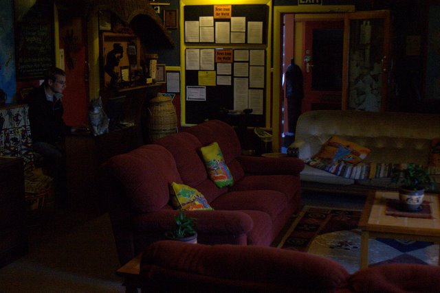 a hostel (or any building) that is a bit drab or not so well taken care of, you tend not to treat it very well. However, the Global Village hostel was nothing like that. First of all, it has an African theme and there is African artwork all over the walls including statues, wooden carvings and paintings. The main lounge had nice sofas to sit on, sofas that you would want in your house. There was a wood burning stove keeping you warm and new age music playing in the background. The kitchen was immaculate, well stocked with dishes, and large. The dining area was nice and there was seating outside. There was a separate TV room with DVDs which is really good so that the noise does not disturb others. The bathrooms had nice, wooden floors and were clean. Our room came with sheets (some places charge extra), was nicely decorated and had heat! There were even hot water bottles set aside in the hall if you wanted to take one to bed. And get this, we were sitting in the common room, writing and talking when the owner came up and offered everyone freshly baked muffins! You could pretty much take the “s” out of hostel. Nils and I spoke reverently about the hostel once we got back into Christchurch and everyone was eager to check it out, especially since such a novel hostel is hard to find.
In the morning, we checked the weather again and unfortunately the predictions were still uncertain for the mountains. We decided to take a risk and started east towards Arthur’s Pass. We passed several signs that gave the status of the highway through the pass. The highway must be prone to deep snow cover and the signs warn if the way is blocked. After driving for some time, the road began a steep ascent up through the mountains. We climbed to the top of the pass and soon came to the town of Arthur’s Pass around 10AM where we hoped to tramp. We visited the information office and were told that snow was on the way. Stations at Mt Cook which is south of Arthur’s Pass were reporting snow which would be arriving around 1PM. The man in the information booth suggested that we hike up the Avalanche Route to the tree line and back which would get us back down before the snow started.
We parked our car near the trailhead and began our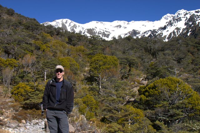 climb. It was pretty cold at the bottom and so we both dressed in layers. It wasn’t a particularly steep climb, but the trail started over loose rock and large rocks to climb over. Most of the way was along a single path that made its way through the trees. Soon after starting we had shed our jackets because the side of the mountain that we were climbing was getting the morning sun so that plus the exertion of climbing was enough to keep us warm. It was a great walk that took us higher than the snow that covered the sides of the mountain. We didn’t make it to the tree line, but had to stop just before to have our lunch. We had to have our car back in Christchurch at a certain time and that dictated how much time we had to walk. On our way down, we ran into a lot of people just walking to the tree line. Chances are the man in the information office told everyone to go up the same route so that if the snow came quicker, it would be easier for rescue to find everyone.


From Arthur’s Pass, we continued east towards Christchurch. The road winds through the mountains and offers amazing views. I had been this way once before when I took the train from Christchurch to Arthur’s Pass and that route is actually better. However, frequent stops were made along the road for photographs.
We got the car back to Christchurch in good time and after a short walk to find a bus, managed to get ourselves back to university.
1 comment:
Nice pictures...
We were in Greymouth last month during a trip round the South Island - just whizzed through on our way to Fox Glacier. Global Village sounds like a great place though, if we'd known about it we might have stayed overnight!
Post a Comment